TORONTO, ONTARIO--(Marketwire - Jan. 31, 2013) - North American Palladium Ltd. ("NAP" or the "Company") (TSX:PDL)(NYSE MKT:PAL) today provided an update on its drill results from the second half of its 2012 underground and surface exploration programs at its Lac des Iles ("LDI") palladium mine property in Northern Ontario.
Highlights:
- Offset Zone underground extension drilling program delivers positive results indicating potential for expanding the resource to the south of and above the current limits of the deposit:
- Hole 12-706 (upper Offset Zone) intersected 21 metres grading 4.19 grams per tonne palladium ("g/t Pd") and hole 12-601 (southern Offset Zone) intersected 10 metres averaging 4.27 g/t Pd;
- Hole 12-706 (upper Offset Zone) intersected 21 metres grading 4.19 grams per tonne palladium ("g/t Pd") and hole 12-601 (southern Offset Zone) intersected 10 metres averaging 4.27 g/t Pd;
- Sheriff Zone near-surface resource potential enhanced by positive definition drilling results featuring broad zones of lower grade palladium mineralization containing local, higher-grade intervals:
- Hole 12-179 intersected 130 metres averaging 1.26 g/t Pd including 24 metres grading 3.05 g/t Pd, and hole 12-185 intersected 106 metres grading 1.40 g/t Pd including 5 metres grading 4.68 g/t Pd;
- Initial resource estimate for the Sheriff Zone expected later in 2013;
- Hole 12-179 intersected 130 metres averaging 1.26 g/t Pd including 24 metres grading 3.05 g/t Pd, and hole 12-185 intersected 106 metres grading 1.40 g/t Pd including 5 metres grading 4.68 g/t Pd;
- Roby Zone north extension drilling program returns high-grade intersections:
- Hole 12-259 intersected 5 metres grading 13.37 g/t Pd and hole 12-269 intersected 24 metres averaging 23.35 g/t Pd, including 3 metres grading 104.20 g/t Pd (amongst the highest ever reported from LDI);
- Hole 12-259 intersected 5 metres grading 13.37 g/t Pd and hole 12-269 intersected 24 metres averaging 23.35 g/t Pd, including 3 metres grading 104.20 g/t Pd (amongst the highest ever reported from LDI);
- North VT Rim surface exploration drilling is starting to demonstrate lateral continuity and returns additional high-grade intercepts and broader zones of pit grade mineralization:
- Hole 12-036 intersected 6 metres with 12.4 g/t Pd including 1 metre grading 54.10 g/t Pd;
- Hole 12-036 intersected 6 metres with 12.4 g/t Pd including 1 metre grading 54.10 g/t Pd;
- New mineralization intersected on the North LDI property (at approximately 400-metre vertical depth on the first of four planned fence holes to be drilled):
- Hole NL 12-100 intersected 2 metres grading 3.58 g/t Pd and 1.08 g/t Pt.
"We are very excited about the prospect of new sources of near-surface, pit-grade ore for our LDI operations," commented André Douchane, Interim CEO and Chairman. "Work has already commenced to advance planning for the Sheriff Zone, which is ideally situated adjacent to our mill. We have a skilled and dedicated project team that is currently assessing the project economics, permitting requirements and production potential."
Mr. Douchane continued: "In addition, excellent results from our Offset Zone and Roby Zone extension drilling, as well as our surface exploration programs highlight the tremendous potential for future resource expansion at LDI."
Lac des Iles Exploration
In 2012, the Company completed a total 50,148 metres of diamond drilling at LDI, of which:
- 19,405 metres were completed on surface projects (Sheriff Zone, North VT Rim and other areas on the Mine Block Intrusion); and
- 30,743 metres on underground exploration and infill programs (Roby and Offset zones).
Since the last exploration update on 2012 drilling (see July 16, 2012 news release), the Company completed 20,656 metres of diamond drilling at LDI, including:
- 5,114 metres at Sheriff;
- 4,952 metres in the southern Offset Zone (12-600 series of holes);
- 3,437 metres in the upper Offset Zone (12-700 series of holes);
- 1,411 metres on the Offset Zone infill program (12-800 series of holes
- 3,350 metres at Roby Zone; and
- 2,392 metres at North VT Rim.
A tabulation of significant palladium ("Pd"), platinum ("Pt"), gold ("Au"), nickel ("Ni"), copper ("Cu") and cobalt ("Co") assays received from drilling completed in the second half of the year are included in the Appendix, with select highlights listed in Tables 1 through 4 below.
The Company is currently working with an independent firm, Tetra Tech, to complete a pre-feasibility study for the LDI property that is expected to be filed in the first quarter of 2013. A key element for the report is an initial declaration of Offset Zone reserves, including an updated mining plan and project economics on only the converted Offset Zone reserves. The Company expects to do a full update on its mineral reserves and resources for the LDI property in the third quarter of 2013.
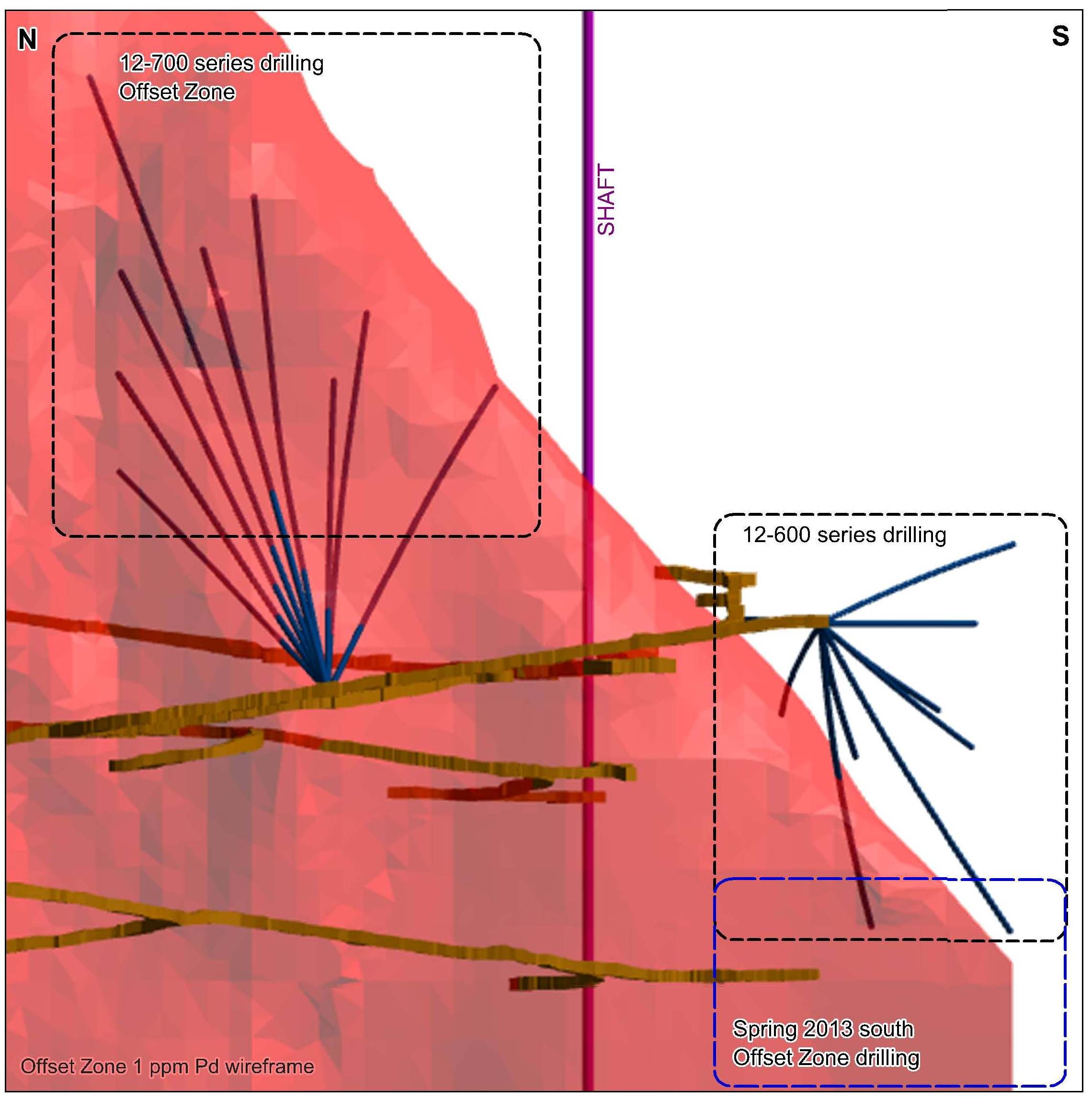
Offset Zone Extension and Infill Drilling
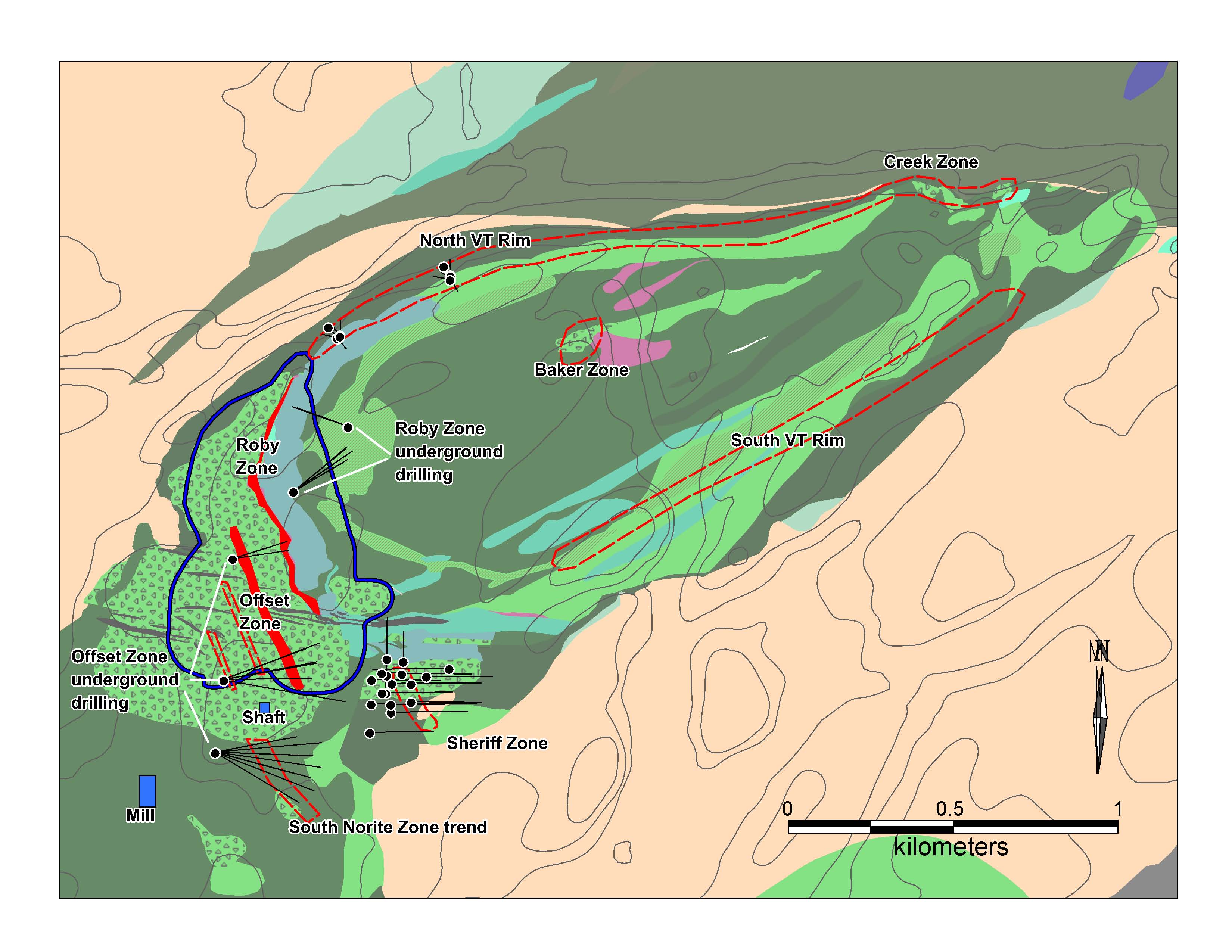
The immediate focus for Offset Zone underground drilling was to extend the resource to the south of the shaft to fill a gap that exists between the main Offset Zone deposit and what has historically been referred to as the Southern Norite Zone (see Figure 1). Additional extension drilling completed last fall targeted the upper parts of the Offset Zone deposit (see Figure 2).
In 2012, infill drilling on approximately 15-metre centres was focused on the northern portion of the upper Offset Zone (see Figure 2). A total of 9,800 metres in 34 diamond drill holes were completed on the extension and infill drilling programs. Estimated true widths are 70-100% of the reported drill intersections in this release. Highlights from the fall 2012 Offset Zone underground drilling program are shown in Table 1 below. The location of the drill holes relative to the most recent resource shell (see July 16, 2012 resource update) is provided in Figure 2. Most of the drilling was completed on the upper part of the zone, to the north of the shaft. In 2013, efforts will focus on the area south of the shaft and adjacent to the initial shaft loading pocket at the 740-metre level.
Mineralization south of the shaft was initially encountered in 2011 drilling (see January 30, 2012 news release), and extension drilling in this area will be the top priority for the underground drilling program in 2013. Infill drilling this year is planned between the 740 and 825-metre mine levels. Considering the close proximity to existing underground infrastructure, a southern extension to the Offset Zone could provide short-term lateral growth options and improved project economics by reducing haulage distances to the initial shaft loading pocket. It would also allow the Company to extend the life of the upper parts of the deposit and provide additional time to complete extension drilling at depth, into the footwall and above the currently defined limits to the deposit.
TABLE 1: Drilling highlights for the Offset Zone south/upper extension and infill programs (fall 2012).
| Zone | Hole # | From (m) | To (m) | Length (m) | Pd (g/t) | Pt (g/t) | Au (g/t) | |
| Offset - South | 12-601 | 160 | 170 | 10 | 4.27 | 0.59 | 0.22 | |
| Offset - South | including | 161 | 165 | 4 | 7.47 | 1.01 | 0.33 | |
| Offset - Upper | 12-701 | 128 | 147 | 19 | 3.16 | 0.31 | 0.33 | |
| Offset - Upper | 12-703 | 228 | 233 | 5 | 5.25 | 0.50 | 0.52 | |
| Offset - Upper | 12-705 | 159 | 192 | 33 | 3.98 | 0.37 | 0.28 | |
| Offset - Upper | including | 171 | 175 | 4 | 14.88 | 1.06 | 0.87 | |
| Offset - Upper | and | 303 | 316 | 13 | 4.20 | 0.51 | 0.16 | |
| Offset - Upper | 12-706 | 197 | 218 | 21 | 4.19 | 0.51 | 0.30 | |
| Offset - Upper | including | 209 | 214 | 5 | 7.40 | 0.98 | 0.45 | |
| Offset - Upper | 12-708 | 271 | 277 | 6 | 4.23 | 0.46 | 0.48 | |
| Offset - Upper | and | 297 | 299 | 2 | 8.13 | 0.86 | 0.51 | |
| Offset - Upper | 12-709 | 307 | 311 | 4 | 8.92 | 0.78 | 0.49 | |
| Offset - Infill | 12-841 | 103 | 129 | 26 | 5.90 | 0.40 | 0.49 |
To view "FIGURE 1: Geological map of the LDI mine block intrusion showing the location of the main mineralized zones. Underground Roby and Offset Zone deposits are shown in red (surface projections). Drilling areas for the fall 2012 exploration program are also indicated", please visit the following link: http://media3.marketwire.com/docs/Figure1NAP.jpg.
To view "FIGURE 2: Longitudinal view, looking east, of the currently defined limits of the Offset Zone (red solid) showing location of the fall 2012 extension drilling program, the shaft and the underground ramp system", please visit the following link: http://media3.marketwire.com/docs/Figure2NAP.jpg.
Sheriff Zone Resource Definition Drilling
In 2012, NAP accelerated surface exploration on both the Sheriff Zone and the North VT Rim targets (see Figure 1). The results from the first phase of the resource definition drilling results at the Sheriff Zone were reported in the Company's July 16, 2012 news release. As part of the second phase of the Sheriff Zone resource definition drilling program, the Company completed 5,114 metres in 17 diamond drill holes. The estimated true width is approximately 70% of the reported intersection length but widths do reach up to 90%. Highlights are shown in Table 3 below.
The second phase of the drilling program is slated for completion later in the first quarter of 2013. After receipt and validation of all drilling results, the Company intends to prepare, in collaboration with Tetra Tech, an initial resource estimate for the Sheriff Zone.
NAP remains optimistic that the Sheriff Zone can provide a near-term source of pit-grade material to help replace mill feed (to be blended with higher-grade Offset Zone feed) that is currently being sourced from the Roby Open Pit. Sampling of split core and/or crush reject material is being conducted for bench-scale metallurgical studies that will commence in February. Bulk sampling, initial pit shell modeling and economic analyses are also being planned for later this year.
TABLE 2: Drilling highlights for the ongoing Phase 2 resource definition program for the Sheriff Zone (fall 2012).
| Zone | Hole # | From (m) | To (m) | Length (m) | Pd (g/t) | Pt (g/t) | Au (g/t) | |
| Sheriff | 12-174 | 81 | 101 | 20 | 2.76 | 0.29 | 0.49 | |
| Sheriff | 12-175 | 47 | 56 | 9 | 3.68 | 0.29 | 0.26 | |
| Sheriff | and | 100 | 199 | 99 | 1.11 | 0.12 | 0.09 | |
| Sheriff | including | 100 | 126 | 26 | 1.93 | 0.19 | 0.13 | |
| Sheriff | including | 104 | 115 | 11 | 2.80 | 0.27 | 0.20 | |
| Sheriff | 12-176 | 106 | 125 | 19 | 1.22 | 0.13 | 0.06 | |
| Sheriff | 12-177 | 19 | 73 | 54 | 1.03 | 0.11 | 0.05 | |
| Sheriff | including | 45 | 59 | 14 | 1.56 | 0.16 | 0.07 | |
| Sheriff | 12-179 | 122 | 252 | 130 | 1.26 | 0.14 | 0.09 | |
| Sheriff | including | 130 | 154 | 24 | 3.05 | 0.33 | 0.20 | |
| Sheriff | including | 141 | 145 | 4 | 7.12 | 0.73 | 0.27 | |
| Sheriff | 12-180 | 80 | 157 | 77 | 1.16 | 0.13 | 0.09 | |
| Sheriff | including | 80 | 91 | 11 | 2.37 | 0.21 | 0.20 | |
| Sheriff | and | 241 | 267 | 26 | 1.05 | 0.14 | 0.05 | |
| Sheriff | 12-181 | 59 | 150 | 91 | 1.06 | 0.11 | 0.07 | |
| Sheriff | including | 59 | 95 | 36 | 1.42 | 0.14 | 0.09 | |
| Sheriff | 12-182 | 62 | 63 | 1 | 6.12 | 0.24 | 0.14 | |
| Sheriff | 12-183 | 140 | 169 | 29 | 1.11 | 0.13 | 0.06 | |
| Sheriff | and | 196 | 210 | 14 | 1.63 | 0.19 | 0.14 | |
| Sheriff | 12-185 | 175 | 281 | 106 | 1.40 | 0.16 | 0.10 | |
| Sheriff | including | 183 | 190 | 7 | 2.65 | 0.26 | 0.14 | |
| Sheriff | and | 327 | 332 | 5 | 4.68 | 0.53 | 0.36 |
Roby Zone Extension Drilling
The Company also completed a program of underground extension drilling on the northern part of the Roby Zone including 3,350 metres in 15 holes. The estimated true width is between 75-95% of the actual drill intersections reported. Highlights from this program are shown in Table 3 below with the drilling areas illustrated in Figure 3. Of note are the excellent grades intersected in hole 12-269 which returned 3 metres at 104.2 g/t Pd - amongst the highest ever reported from LDI.
TABLE 3: Drilling highlights for the Roby Zone north extension program (fall 2012).
| Zone | Hole # | From (m) | To (m) | Length (m) | Pd (g/t) | Pt (g/t) | Au (g/t) | |
| Roby - North | 12-259 | 160 | 165 | 5 | 13.37 | 0.57 | 0.23 | |
| Roby - North | 12-261 | 168 | 172 | 4 | 5.56 | 0.30 | 0.05 | |
| Roby - North | 12-262 | 169 | 175 | 6 | 4.70 | 0.28 | 0.05 | |
| Roby - North | and | 193 | 200 | 7 | 7.09 | 0.33 | 0.31 | |
| Roby - North | 12-269 | 138 | 162 | 24 | 23.35 | 0.98 | 0.68 | |
| Roby - North | including | 146 | 149 | 3 | 104.20 | 4.30 | 4.13 |
To view "FIGURE 3: Longitudinal view, looking east, of the currently defined limits to the Roby Zone (red solid) showing location of the fall 2012 extension drilling program and the underground ramp system", please visit the following link: http://media3.marketwire.com/docs/Figure3NAP.jpg.
North VT Rim Surface Drilling
Historical exploration on the northern margin of the Mine Block Intrusion by NAP has defined a zone of low-sulfide palladium-rich mineralization referred to as the North VT Rim trend. The trend is characterized by significant local grade variability as indicated by the 'bonanza' palladium and adjacent low-grade trench results reported last year (see January 30th, 2012 news release).
The North VT Rim trend has not been systematically drilled off yet, but based on existing trenching and drilling results, may have lateral continuity at or near surface over a distance of at least five hundred metres - extending east from the northeast end of the Roby Zone (see Figure 1). The trend remains open further to the east and may extend as far east as the Creek Zone for a potential total strike length of 2 kilometres (see Figure 1).
Based on the most recent drilling results, the North VT Rim trend appears to have a southerly dip of approximately 50°- 55° and strikes parallel to the geology of the Mine Block Intrusion in this area. In the fall of 2012, the Company completed 2,392 metres over 26 holes of surface exploration diamond drilling on the North VT Rim trend. Holes were arranged in fans to ensure a tight spacing (approximately 10-metre centres) of pierce points on the mineralized trend. Drilling was concentrated in the upper 50 metres of the trend and in two areas separated by approximately 400 metres. This drill hole layout was designed to provide additional insights into both local 3D and along strike 2D grade variability. The estimated true widths are between 50-90% of the actual drill intersections reported. Highlights are shown in Table 4 below.
The Company is conducting applied mineralogical research on selected trench samples from the North VT Rim trend. The research is being conducted at the Micro Analytical Facility at Brandon University, Manitoba.
TABLE 4: Surface drilling highlights for the North VT rim exploration program (fall 2012).
| Zone | Hole # | From (m) | To (m) | Length (m) | Pd (g/t) | Pt (g/t) | Au (g/t) | |
| North VT Rim | 12-031 | 18 | 22 | 4 | 4.67 | 0.26 | 0.06 | |
| North VT Rim | 12-033 | 21 | 25 | 4 | 5.10 | 0.21 | 0.05 | |
| North VT Rim | 12-034 | 15 | 31 | 16 | 2.21 | 0.14 | 0.02 | |
| North VT Rim | 12-035 | 37 | 41 | 4 | 5.05 | 0.50 | 0.09 | |
| North VT Rim | 12-036 | 18 | 24 | 6 | 12.40 | 0.38 | 0.16 | |
| North VT Rim | including | 23 | 24 | 1 | 54.10 | 1.32 | 0.59 | |
| North VT Rim | 12-037 | 18 | 32 | 14 | 1.98 | 0.12 | 0.04 | |
| North VT Rim | 12-038 | 20 | 30 | 10 | 2.21 | 0.12 | 0.04 | |
| North VT Rim | 12-039 | 21 | 28 | 7 | 4.70 | 0.18 | 0.07 | |
| North VT Rim | 12-041 | 22 | 29 | 7 | 3.84 | 0.17 | 0.09 | |
| North VT Rim | 12-042 | 24 | 31 | 7 | 6.29 | 0.24 | 0.16 | |
| North VT Rim | including | 25 | 26 | 1 | 23.40 | 0.83 | 0.85 | |
| North VT Rim | 12-043 | 14 | 15 | 1 | 21.00 | 1.18 | 0.06 | |
| North VT Rim | 12-047 | 20 | 22 | 2 | 15.10 | 1.05 | 0.12 |
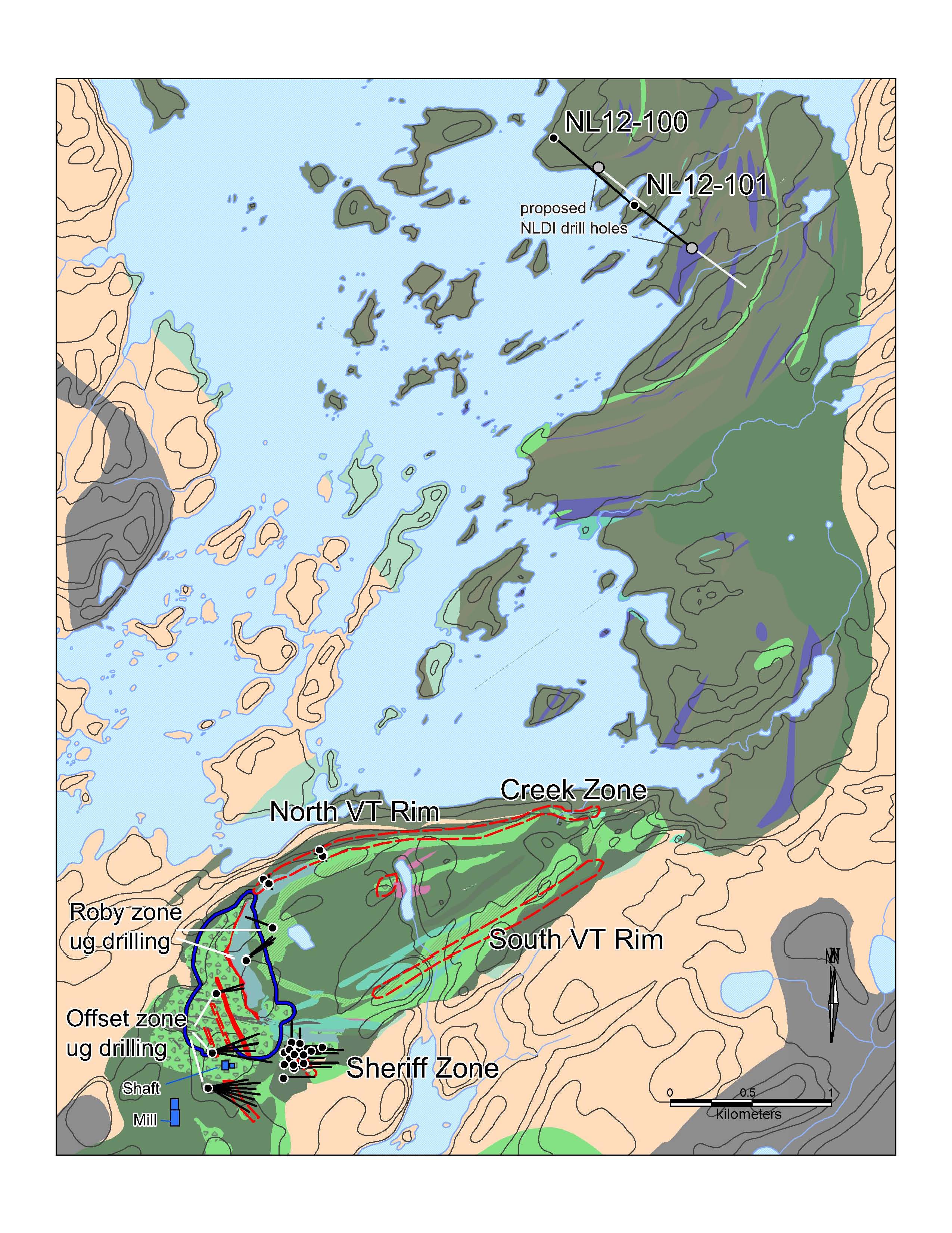
North LDI Intrusion Surface Drilling
Historical exploration on the North LDI intrusion has identified numerous surface occurrences of anomalous palladium mineralization from 0.1 to 4.0 g/t and generally associated with pyroxenite and peridotite layers and disseminated magmatic sulfide mineralization. There has been limited surface drilling by NAP on the North LDI complex (a total of 3,420 metres in 7 diamond drill holes completed in 2003 and 2009). The geology, geochemistry and mineral potential of the North LDI intrusion is currently being studied by NAP in collaboration with an academic study at Queens University, Ontario.
NAP recently completed an airborne magnetic and electromagnetic survey (Geotech Ltd.'s VTEM system - see December 11, 2012 news release) that returned both magnetic and electromagnetic anomalies that helped focus plans for drilling. In the summer of 2012, the Company laid out a fence of four holes designed to better establish the 3D geology and grade distributions on the better exposed eastern part of the intrusion (see Figure 4).
Two of these holes (NL 12-100 and NL 12-101) were completed in the fall of 2012 (total of 2,148 metres) and results have been received for one of these (hole NL 12-100), which intersected a previously unrecognized interval of PGE mineralization at a vertical depth of approximately 400 metres. The intersection cut 2 metres at 3.58 g/t Pd and 1.08 g/t Pt within a broader zone of anomalous palladium and platinum values (e.g., 9 metres at 1.03 g/t Pd; see Appendix). The true width of the mineralization is estimated to be 1.88 metres. It is not yet known if this zone has lateral continuity or what deposit model best fits the observed petrological and mineralogical characteristics. The Company expects to complete the four hole fence later this year and will provide an update on North LDI exploration as new results are received.
To view "FIGURE 4: Geological map for the North LDI intrusion and the LDI mine block intrusion showing the location of the planned four hole fence of surface diamond drill holes at North LDI. Two holes (NL 12-100, NL 12-101) were completed in the fall of 2012", please visit the following link: http://media3.marketwire.com/docs/Figure4NAP.jpg.
2013 Exploration Plans
In 2013, NAP's LDI exploration program will be focused on defining extensions to both the Offset Zone and Roby Zone resources and on identifying additional, pit-grade material at surface. Surface exploration will be focused on the Sheriff Zone and the North VT Rim trend and are expected to include the first systematic drilling on the South VT Rim target (see Figures 1 and 4).
Greenfields exploration activity will continue in 2013 with the completion of the Phase 1 drilling program expected by the end of February. A total of 5,000 metres of drilling is expected to be completed in the first quarter of 2013, bringing the total for the program to approximately 12,000 metres (see Figure 5). A comprehensive review of the large amount of technical data that has been acquired for the Company's greenfields properties will be undertaken in the second quarter of 2013. The outcomes of this review will include a definition and ranking of exploration drill targets that could be pursued later in the year.
To view "FIGURE 5: Outline of greenfields PGE exploration properties relative to the Mine Block property and LDI operations showing expected drilling for Phase 1. All of the greenfields properties are located within 30 kilometers of the LDI mill", please visit the following link: http://media3.marketwire.com/docs/Figure5NAP.jpg.
Technical Information and Qualified Persons
The assay analyses performed during NAP's exploration drilling programs are subject to a formal quality assurance and quality control program. Diamond drill core from exploration drilling is logged and sampled on the mine site and at the Company's exploration office in Thunder Bay with sample transport by the Company and Courtesy Courier to Activation Laboratories Ltd. (Thunder Bay and Ancaster), an independent accredited laboratory, for assay analysis. Check assay analyses are carried out by SGS Minerals Services (Toronto), a laboratory that is also independent of the Company.
The Company's exploration team designed and executed the drilling program under the supervision of Cameron McLean, P. Geo., an employee of NAP and a Qualified Person as defined by National Instrument 43-101, who has reviewed and approved the content of this news release.
About North American Palladium
NAP is an established precious metals producer that has been operating its flagship Lac des Iles mine (LDI) located in Ontario, Canada since 1993. LDI is one of only two primary producers of palladium in the world, and is currently undergoing a major expansion to increase production and reduce cash costs per ounce. NAP also operates the Vezza gold mine located in the Abitibi region of Quebec. The Company's shares trade on the NYSE MKT under the symbol PAL and on the TSX under the symbol PDL.
Cautionary Statement on Forward-Looking Information
Certain information included in this news release constitutes 'forward-looking statements' within the meaning of the 'safe harbor' provisions of the United States Private Securities Litigation Reform Act of 1995 and Canadian securities laws. The words 'expect', 'believe', 'will', 'intend', 'estimate', 'forecast', and similar expressions identify forward-looking statements. Such statements include, without limitation, any information as to our future exploration results, financial or operating performance, including: statements with respect to the exploration potential of the LDI or greenfields properties, projected grades and other statements that express management's expectations or estimates of future performance. Forward-looking statements are necessarily based upon a number of factors and assumptions that, while considered reasonable by management, are inherently subject to significant business, economic and competitive uncertainties and contingencies. The factors and assumptions contained in this news release, which may prove to be incorrect, include, but are not limited to: that the Company's interpretations of the ore body are accurate, that prices for key exploration and development supplies, including labour, will remain consistent with the Company's expectations, that the Company's current estimates of mineral reserves and resources are accurate, and that there are no material delays in the timing of ongoing projects. The forward-looking statements are not guarantees of future performance. The Company cautions the reader that such forward-looking statements involve known and unknown risks that may cause the actual results to be materially different from those expressed or implied by the forward-looking statements. Such risks include, but are not limited to: the possibility that new exploration targets may not meet management's expectations, uncertainty of mineral reserves and resources, inherent risks associated with exploration and development, the risk that the Offset Zone and other zones may not be successfully developed, and uncertainty of the ability of the Company to obtain financing. For more details on the factors, assumptions and risks see the Company's most recent Form 40-F/Annual Information Form on file with the U.S. Securities and Exchange Commission and Canadian provincial securities regulatory authorities. The Company disclaims any obligation to update or revise any forward-looking statements, whether as a result of new information, events or otherwise, except as expressly required by law. Readers are cautioned not to put undue reliance on these forward-looking statements.
| APPENDIX: | ||||||||||||||||
| Zone | Hole Number | From (m) | To (m) | Length (m) | Pd (g/t) | Pt (g/t) | Au (g/t) | Cu (%) | Ni (%) | Co (%) | ||||||
| North VT Rim | 12-031 | 18.00 | 22.00 | 4.00 | 4.67 | 0.26 | 0.06 | 0.002 | 0.027 | 0.0039 | ||||||
| North VT Rim | 12-033 | 21.00 | 25.00 | 4.00 | 5.10 | 0.21 | 0.05 | 0.003 | 0.025 | 0.0036 | ||||||
| North VT Rim | 12-034 | 15.00 | 31.00 | 16.00 | 2.21 | 0.14 | 0.02 | 0.003 | 0.026 | 0.0039 | ||||||
| North VT Rim | 12-035 | 37.00 | 41.00 | 4.00 | 5.05 | 0.50 | 0.09 | 0.008 | 0.028 | 0.0039 | ||||||
| North VT Rim | 12-036 | 18.00 | 24.00 | 6.00 | 12.40 | 0.38 | 0.16 | 0.008 | 0.030 | 0.0043 | ||||||
| North VT Rim | including | 23.00 | 24.00 | 1.00 | 54.10 | 1.32 | 0.59 | 0.028 | 0.053 | 0.0059 | ||||||
| North VT Rim | 12-037 | 18.00 | 32.00 | 14.00 | 1.98 | 0.12 | 0.04 | 0.005 | 0.028 | 0.0044 | ||||||
| North VT Rim | 12-038 | 20.00 | 30.00 | 10.00 | 2.21 | 0.12 | 0.04 | 0.004 | 0.027 | 0.0041 | ||||||
| North VT Rim | 12-039 | 21.00 | 28.00 | 7.00 | 4.70 | 0.18 | 0.07 | 0.003 | 0.024 | 0.0036 | ||||||
| North VT Rim | 12-041 | 22.00 | 29.00 | 7.00 | 3.84 | 0.17 | 0.09 | 0.007 | 0.030 | 0.0043 | ||||||
| North VT Rim | 12-042 | 24.00 | 31.00 | 7.00 | 6.29 | 0.24 | 0.16 | 0.010 | 0.033 | 0.0041 | ||||||
| North VT Rim | including | 25.00 | 26.00 | 1.00 | 23.40 | 0.83 | 0.85 | 0.058 | 0.073 | 0.0059 | ||||||
| North VT Rim | 12-043 | 14.00 | 15.00 | 1.00 | 21.00 | 1.18 | 0.06 | 0.001 | 0.018 | 0.0029 | ||||||
| North VT Rim | 12-047 | 20.00 | 22.00 | 2.00 | 15.10 | 1.05 | 0.12 | 0.006 | 0.028 | 0.0043 | ||||||
| Sheriff | 12-174 | 81.00 | 101.00 | 20.00 | 2.76 | 0.29 | 0.49 | 0.109 | 0.129 | 0.0076 | ||||||
| Sheriff | 12-175 | 47.00 | 56.00 | 9.00 | 3.68 | 0.29 | 0.26 | 0.099 | 0.091 | 0.0085 | ||||||
| Sheriff | and | 100.00 | 199.00 | 99.00 | 1.11 | 0.12 | 0.09 | 0.032 | 0.048 | 0.0066 | ||||||
| Sheriff | including | 100.00 | 126.00 | 26.00 | 1.93 | 0.19 | 0.13 | 0.040 | 0.063 | 0.0081 | ||||||
| Sheriff | including | 104.00 | 115.00 | 11.00 | 2.80 | 0.27 | 0.20 | 0.053 | 0.080 | 0.0088 | ||||||
| Sheriff | 12-176 | 106.00 | 125.00 | 19.00 | 1.22 | 0.13 | 0.06 | 0.023 | 0.035 | 0.0058 | ||||||
| Sheriff | 12-177 | 19.00 | 73.00 | 54.00 | 1.03 | 0.11 | 0.05 | 0.023 | 0.035 | 0.0048 | ||||||
| Sheriff | including | 45.00 | 59.00 | 14.00 | 1.56 | 0.16 | 0.07 | 0.021 | 0.033 | 0.0047 | ||||||
| Sheriff | 12-179 | 122.00 | 252.00 | 130.00 | 1.26 | 0.14 | 0.09 | 0.037 | 0.053 | 0.0074 | ||||||
| Sheriff | including | 130.00 | 154.00 | 24.00 | 3.05 | 0.33 | 0.20 | 0.065 | 0.082 | 0.0101 | ||||||
| Sheriff | including | 141.00 | 145.00 | 4.00 | 7.12 | 0.73 | 0.27 | 0.124 | 0.138 | 0.0118 | ||||||
| Sheriff | 12-180 | 80.00 | 157.00 | 77.00 | 1.16 | 0.13 | 0.09 | 0.054 | 0.053 | 0.0067 | ||||||
| Sheriff | including | 80.00 | 91.00 | 11.00 | 2.37 | 0.21 | 0.20 | 0.127 | 0.093 | 0.0081 | ||||||
| Sheriff | and | 241.00 | 267.00 | 26.00 | 1.05 | 0.14 | 0.05 | 0.016 | 0.036 | 0.0046 | ||||||
| Sheriff | 12-181 | 59.00 | 150.00 | 91.00 | 1.06 | 0.11 | 0.07 | 0.043 | 0.051 | 0.0062 | ||||||
| Sheriff | including | 59.00 | 95.00 | 36.00 | 1.42 | 0.14 | 0.09 | 0.041 | 0.052 | 0.0060 | ||||||
| Sheriff | 12-182 | 62.00 | 63.00 | 1.00 | 6.12 | 0.24 | 0.14 | 0.071 | 0.048 | 0.0046 | ||||||
| Sheriff | 12-183 | 140.00 | 169.00 | 29.00 | 1.11 | 0.13 | 0.06 | 0.043 | 0.052 | 0.0079 | ||||||
| Sheriff | and | 196.00 | 210.00 | 14.00 | 1.63 | 0.19 | 0.14 | 0.058 | 0.059 | 0.0067 | ||||||
| Sheriff | 12-185 | 175.00 | 281.00 | 106.00 | 1.40 | 0.16 | 0.10 | 0.160 | 0.010 | 0.0099 | ||||||
| Sheriff | including | 183.00 | 190.00 | 7.00 | 2.65 | 0.26 | 0.14 | 0.061 | 0.067 | 0.0079 | ||||||
| Sheriff | and | 327.00 | 332.00 | 5.00 | 4.68 | 0.53 | 0.36 | 0.133 | 0.138 | 0.0087 | ||||||
| Offset -South | 12-601 | 160.00 | 170.00 | 10.00 | 4.27 | 0.59 | 0.22 | 0.082 | 0.132 | 0.0111 | ||||||
| Offset -South | including | 161.00 | 165.00 | 4.00 | 7.47 | 1.01 | 0.33 | 0.118 | 0.193 | 0.0119 | ||||||
| Offset -Upper | 12-701 | 128.00 | 147.00 | 19.00 | 3.16 | 0.31 | 0.33 | 0.085 | 0.092 | 0.0076 | ||||||
| Offset -Upper | 12-703 | 228.00 | 233.00 | 5.00 | 5.25 | 0.50 | 0.52 | 0.070 | 0.086 | 0.0100 | ||||||
| Offset -Upper | 12-705 | 159.00 | 192.00 | 33.00 | 3.98 | 0.37 | 0.28 | 0.080 | 0.101 | 0.0075 | ||||||
| Offset -Upper | including | 171.00 | 175.00 | 4.00 | 14.88 | 1.06 | 0.87 | 0.121 | 0.116 | 0.0066 | ||||||
| Offset -Upper | and | 303.00 | 316.00 | 13.00 | 4.20 | 0.51 | 0.16 | 0.249 | 0.203 | 0.0129 | ||||||
| Offset -Upper | 12-706 | 197.00 | 218.00 | 21.00 | 4.19 | 0.51 | 0.30 | 0.094 | 0.099 | 0.0098 | ||||||
| Offset -Upper | including | 209.00 | 214.00 | 5.00 | 7.40 | 0.98 | 0.45 | 0.187 | 0.152 | 0.0134 | ||||||
| Offset -Upper | 12-708 | 271.00 | 277.00 | 6.00 | 4.23 | 0.46 | 0.48 | 0.129 | 0.133 | 0.0105 | ||||||
| Offset -Upper | and | 297.00 | 299.00 | 2.00 | 8.13 | 0.86 | 0.51 | 0.194 | 0.164 | 0.0116 | ||||||
| Offset -Upper | 12-709 | 307.00 | 311.00 | 4.00 | 8.92 | 0.78 | 0.49 | 0.255 | 0.168 | 0.0138 | ||||||
| Offset -Infill | 12-841 | 103.00 | 129.00 | 26.00 | 5.90 | 0.40 | 0.49 | 0.105 | 0.156 | 0.0068 | ||||||
| Roby - North | 12-259 | 160.00 | 165.00 | 5.00 | 13.37 | 0.57 | 0.23 | 0.015 | 0.052 | 0.0056 | ||||||
| Roby - North | 12-261 | 168.00 | 172.00 | 4.00 | 5.56 | 0.30 | 0.05 | 0.004 | 0.034 | 0.0043 | ||||||
| Roby - North | 12-262 | 169.00 | 175.00 | 6.00 | 4.70 | 0.28 | 0.05 | 0.005 | 0.029 | 0.0040 | ||||||
| Roby - North | and | 193.00 | 200.00 | 7.00 | 7.09 | 0.33 | 0.31 | 0.029 | 0.048 | 0.0047 | ||||||
| Roby - North | 12-269 | 138.00 | 162.00 | 24.00 | 23.35 | 0.98 | 0.68 | 0.013 | 0.054 | 0.0057 | ||||||
| Roby - North | including | 146.00 | 149.00 | 3.00 | 104.20 | 4.30 | 4.13 | 0.033 | 0.086 | 0.0050 | ||||||
| North LDI | NL12-100 | 549.00 | 558.00 | 9.00 | 1.03 | 0.32 | 0.04 | 0.008 | 0.050 | 0.0081 | ||||||
| including | 549.00 | 551.00 | 2.00 | 3.58 | 1.08 | 0.12 | 0.031 | 0.086 | 0.0156 | |||||||
Contact Information:
Camilla Bartosiewicz
Director, Investor Relations and Corporate Communications
416-360-7374
camilla@nap.com
www.nap.com