VANCOUVER, BRITISH COLUMBIA--(Marketwire - July 5, 2011) - Gold Canyon Resources Inc. (TSX VENTURE:GCU)(PINK SHEETS:GDCRF) ("Gold Canyon" or "the Company") is pleased to announce progress on multiple fronts at its 100% controlled Springpole Gold Project, located 110 kilometers northeast of the Red Lake Mining Camp, Ontario, Canada.
Summary of Activity Discussed in this News Release:
- Initial gold and silver recoveries from eight bottle roll tests conducted on Portage Zone material have been received and indicate good recoveries for both metals. Average peak recoveries for gold are 80.1% and for silver, 75.1%. Advanced testing will begin shortly on core from a series of four metallurgical holes currently being drilled at Springpole.
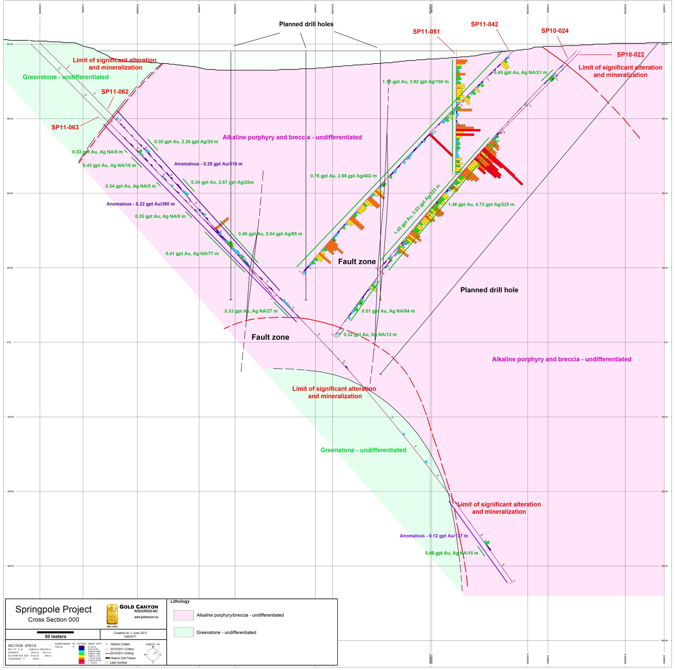
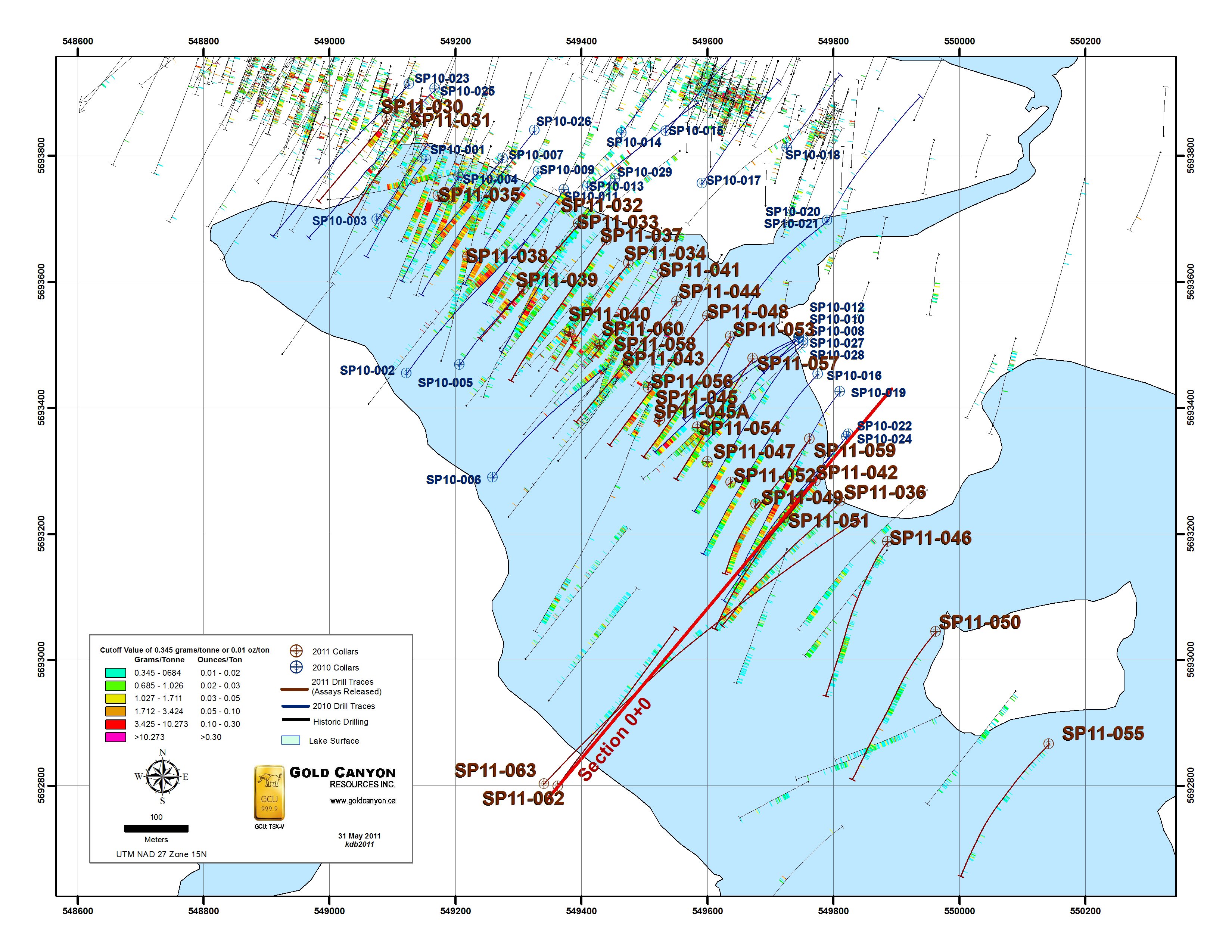
- Assays have returned from the first successful deep drill hole (SP11-063) to test the down dip projection of the Portage Zone. This hole encountered numerous intervals of low-grade gold mineralization (see attached cross section and map) along the margin of the alkaline porphyry- breccia complex. Lithologic data from this hole suggests the Portage Zone may be dipping to the northeast in this area. To test this, a second deep hole is planned on this same section; however, drilling in the opposite direction.
- To view the Cross Section associated with this release, please click the following link: http://media3.marketwire.com/docs/Cross%20Section%20GCU.jpg.
- To view the Plan Map associated with this release, please click the following link: http://media3.marketwire.com/docs/Plan%20Map%20GCU.jpg.
- Complete silver assays have returned for all holes from the Winter 2011 Drill Program and continue to indicate consistent significant silver mineralization accompanies gold mineralization at Springpole. Interestingly, the silver-to-gold ratio is as high as 20.9-to-1 in hole SP11-055, the southeast-most drill hole yet drilled in the current drill campaign. This increase may be evidence of metal zonation within the mineralized system.
- The Summer 2011 Drill Program has commenced. Two land-based drills are presently drilling additional deep tests and metallurgical holes. Two barge-based drills are now scheduled to start mid-July. Four drills are scheduled to operate at site from mid-July through November.
Initial Bottle Roll Results
A suite of eight samples of mineralized material from the Portage Zone were recently submitted to SGS Canada Inc. in Vancouver for bottle roll leach testing for gold and silver. Bottle roll tests were conducted on pulverized material (>80%, 65-70 microns) using a 1 gram NaCN per liter buffered solution for 96 hours.
Peak gold recovery for most samples was reached within 36 hours. Peak gold recoveries range from 70-93% and average 80.1%. Calculated CN consumption is moderate ranging from 0.30-1.51 kg/t, and CaO consumption was small, -0.08-0.58 kg/t, probably due to the alkaline nature of the mineralization.
Peak silver recovery lagged behind peak gold recovery with most samples showing peak silver recovery between 48-96 hours. Peak silver recoveries range from 52-88% and average 75.1%.
"Our initial bottle roll results indicate good recoveries for both gold and silver at Springpole," comments Dr. Quinton Hennigh, Technical Advisor and Director of Gold Canyon Resources. "We are presently drilling a series of four holes to be used for additional metallurgical test work in which conditions will be explored for optimizing recoveries."
To view the Summary of Au and Ag Recoveries from Bottle Roll Tests on Eight Mineralized Portage Zone Samples table, please click the following link: http://media3.marketwire.com/docs/Bottle%20Roll%20Tests%20GCU.pdf.
Assays have returned for the first successful deep hole drilled at Springpole. Diamond drill hole SP11-063 was collared on the southwest shore of Portage Bay and oriented at 050 degrees true north and a -45 degree inclination (see attached map and section). This hole twinned hole SP11-062, the first attempted deep hole, which was lost in broken ground at a depth of 456 meters. SP11-063 veered sharply to the right, the end of the hole falling approximately 150 meters south of its intended target, but it managed to reach a down hole depth of 975 meters making it the longest hole yet drilled at Springpole.
Drill hole SP11-063 appears to have drilled sub-parallel to the margin of the alkaline porphyry-breccia complex which appears to be dipping northeast in this area rather than having a nearly vertical dip as first believed. SP11-063 encountered numerous intercepts of low-grade gold mineralization. A second deep hole is planned on this same section, but drilling in the opposite direction to determine if the Portage Zone indeed dips northeast.
"Analyzing the results from SP11-063," comments Hennigh, "this hole is possibly telling us some important information. If the Portage Zone is indeed dipping northeast, it would suggest previous drill intercepts in holes SP10-022 and -024 and SP11-042 more closely reflect true width of the Portage Zone in this area. In other words, it might be wider than we first thought. Once we drill a deep hole in the opposite direction on this same section we will be able to confidently estimate the true dip and width of the Portage Zone."
| Summary of Results from SP11-062 and -063 | |||||||||||||||
|
Hole |
From (m) |
To (m) |
Len- gth (m) |
Gold (grams per tonne) |
Silver (grams per tonne) |
Len- gth (feet) |
Gold (oz per ton) |
Silver (oz per ton) |
Silver -to- Gold Ratio |
||||||
| SP11-062 | 190.0 | 214.0 | 24.0 | 0.30 | 2.26 | 79 | 0.009 | 0.066 | 7.5 | ||||||
| 265.0 | 290.0 | 25.0 | 0.34 | 2.67 | 82 | 0.010 | 0.078 | 7.9 | |||||||
| 337.0 | 422.0 | 85.0 | 0.40 | 5.04 | 279 | 0.012 | 0.147 | 12.6 | |||||||
| A zone of no recovery was encountered from 408-411 meters | |||||||||||||||
| SP11-063 | 189.0 | 194.0 | 5.0 | 0.33 | in process | 16 | 0.010 | in process | N/A | ||||||
| 203.0 | 221.0 | 18.0 | 0.43 | in process | 59 | 0.013 | in process | N/A | |||||||
| 250.0 | 255.0 | 5.0 | 0.34 | in process | 16 | 0.010 | in process | N/A | |||||||
| 312.0 | 317.0 | 5.0 | 0.35 | in process | 16 | 0.010 | in process | N/A | |||||||
| 342.0 | 419.0 | 77.0 | 0.41 | in process | 253 | 0.012 | in process | N/A | |||||||
| 477.0 | 504.0 | 27.0 | 0.33 | in process | 89 | 0.010 | in process | N/A | |||||||
| 909.0 | 924.0 | 15.0 | 0.48 | in process | 49 | 0.014 | in process | N/A | |||||||
| Zones of no recovery were encountered from 456-457.7 and 460-460.5 meters |
| Weighted averages were used to calculate all reported intervals. |
| Zone of no core recovery was given a gold grade of 0 in the weighted average calculations above. |
| Reported intervals apply a 0.2 gram per tonne gold (0.006 oz per ton gold) lower cutoff. |
| Internal dilution within reported intervals does not exceed core lengths of 8 meters. |
| 1 troy oz = 31.103 grams |
| Conversion factor - grams per tonne to troy oz per short ton; g/t divided by 34.2857 or g/t multiplied by 0.0292 |
| 1 meter = 3.28 feet |
Complete Gold and Silver Results from Winter 2011 Drill Program
Complete gold and silver results from the Winter 2011 Drill Program are listed in the attached table. Silver results for holes SP11-042, -055, -057, -059 and -060 are new. All other results have been released in previous news releases between February and May, 2011.
The new silver results reported here continue to indicate gold mineralization is consistently accompanied by appreciable silver in the Portage Zone. Interestingly, the silver-to-gold ratio is as high as 20.9-to-1 in hole SP11-055, the southeast-most drill hole yet drilled in the current drill campaign. This increase may be evidence of metal zonation within the mineralized system.
Summary of Gold and Silver Results from the 2011 Winter Drill Program
| Hole |
From (m) |
To (m) |
Length (m) |
Gold (grams per tonne) |
Silver (grams per tonne) |
Length (feet) |
Gold (oz per ton) |
Silver (oz per ton) |
Silver -to- Gold Ratio |
|
| SP11-030 | 14.0 | 73.0 | 59.0 | 2.51 | 1.98 | 194 | 0.073 | 0.058 | 0.79 | |
| includes | 25.0 | 66.0 | 41.0 | 3.32 | 2.70 | 134 | 0.097 | 0.079 | 0.81 | |
| includes | 30.0 | 41.0 | 11.0 | 7.28 | 6.79 | 36 | 0.213 | 0.198 | 0.93 | |
| includes | 34.0 | 37.0 | 3.0 | 12.69 | 9.93 | 10 | 0.371 | 0.290 | 0.78 | |
| SP11-031 | 5.4 | 91.0 | 85.6 | 1.09 | 0.77 | 281 | 0.032 | 0.022 | 0.71 | |
| includes | 23.0 | 53.0 | 30.0 | 1.45 | 1.08 | 98 | 0.042 | 0.032 | 0.74 | |
| includes | 65.0 | 91.0 | 26.0 | 1.38 | 1.19 | 85 | 0.040 | 0.035 | 0.86 | |
| includes | 82.0 | 87.0 | 5.0 | 3.12 | 2.12 | 16 | 0.091 | 0.062 | 0.68 | |
| SP11-032 | 13.0 | 70.0 | 57.0 | 0.54 | 4.39 | 187 | 0.016 | 0.128 | 8.13 | |
| SP11-033 | 13.0 | 315.0 | 302.0 | 1.39 | 7.16 | 991 | 0.041 | 0.209 | 5.15 | |
| includes | 13.0 | 278.0 | 265.0 | 1.52 | 7.84 | 869 | 0.044 | 0.229 | 5.16 | |
| includes | 200.0 | 208.0 | 8.0 | 2.29 | 25.48 | 26 | 0.067 | 0.744 | 11.13 | |
| includes | 228.0 | 278.0 | 50.0 | 5.45 | 26.19 | 164 | 0.159 | 0.765 | 4.81 | |
| includes | 228.0 | 253.0 | 25.0 | 8.81 | 46.90 | 82 | 0.257 | 1.369 | 5.32 | |
| includes | 230.0 | 233.0 | 3.0 | 53.88 | 45.93 | 10 | 1.573 | 1.341 | 0.85 | |
| includes | 230.0 | 231.0 | 1.0 | 126.51 | 61.50 | 3 | 3.694 | 1.796 | 0.49 | |
| includes | 274.0 | 275.5 | 1.5 | 14.40 | 25.95 | 5 | 0.420 | 0.758 | 1.80 | |
| Intervals of no core recovery were encountered at 146.5-148.0, 203.5-205.0, 235.0-236.5, 239.5-244.0 and 302.5-304.0 m | ||||||||||
| SP11-034 | 37.0 | 110.5 | 73.5 | 1.18 | 6.18 | 241 | 0.034 | 0.180 | 5.24 | |
| includes | 76.0 | 109.5 | 33.5 | 1.56 | 4.47 | 110 | 0.046 | 0.131 | 2.87 | |
| 162.0 | 331.0 | 169.0 | 1.08 | 6.29 | 554 | 0.032 | 0.184 | 5.82 | ||
| includes | 246.0 | 297.0 | 51.0 | 2.20 | 11.91 | 167 | 0.064 | 0.348 | 5.41 | |
| includes | 246.0 | 249.0 | 3.0 | 18.51 | 252.60 | 10 | 0.540 | 7.376 | 13.65 | |
| Intervals of no core recovery were encountered at 249.0-256.5, 258.0-259.5, 261.0-265.5, 270.0-271.5, 277.5-279.0, 285.0-286.5 and 298.5-300.0 m | ||||||||||
| SP11-035 | 16.0 | 20.0 | 4.0 | 0.31 | 0.58 | 13 | 0.009 | 0.017 | 1.87 | |
| 37.0 | 68.0 | 31.0 | 1.01 | 3.60 | 102 | 0.029 | 0.105 | 3.56 | ||
| includes | 41.0 | 45.0 | 4.0 | 4.14 | 16.28 | 13 | 0.121 | 0.475 | 3.93 | |
| 89.0 | 96.0 | 7.0 | 0.35 | 0.60 | 23 | 0.010 | 0.018 | 1.71 | ||
| 105.0 | 200.5 | 95.5 | 1.22 | 3.26 | 313 | 0.036 | 0.095 | 2.67 | ||
| includes | 126.0 | 144.0 | 18.0 | 1.53 | 2.96 | 59 | 0.045 | 0.086 | 1.93 | |
| includes | 150.0 | 170.0 | 20.0 | 1.58 | 3.47 | 66 | 0.046 | 0.101 | 2.20 | |
| includes | 178.5 | 200.5 | 22.0 | 1.61 | 4.38 | 72 | 0.047 | 0.128 | 2.72 | |
| SP11-036 | 50.0 | 58.0 | 8.0 | 0.34 | 0.96 | 26 | 0.010 | 0.028 | 2.82 | |
| 66.0 | 73.0 | 7.0 | 0.34 | 1.45 | 23 | 0.010 | 0.042 | 4.26 | ||
| 87.0 | 110.0 | 23.0 | 0.68 | 1.65 | 75 | 0.020 | 0.048 | 2.43 | ||
| 138.0 | 163.0 | 25.0 | 0.54 | 1.59 | 82 | 0.016 | 0.046 | 2.94 | ||
| 204.0 | 394.5 | 190.5 | 0.90 | 3.96 | 625 | 0.026 | 0.116 | 4.40 | ||
| includes | 235.0 | 373.5 | 138.5 | 1.13 | 5.07 | 454 | 0.033 | 0.148 | 4.49 | |
| includes | 276.0 | 303.0 | 27.0 | 2.09 | 8.89 | 89 | 0.061 | 0.260 | 4.25 | |
| Intervals of no core recovery were encountered at 355.6-358.5, 373.5-376.5, 379.5-382.5 and 385.5-391.5 m | ||||||||||
| SP11-037 | 21.0 | 36.0 | 15.0 | 0.47 | 1.27 | 49 | 0.014 | 0.037 | 2.70 | |
| 54.0 | 316.5 | 262.5 | 0.92 | 4.67 | 861 | 0.027 | 0.136 | 5.08 | ||
| includes | 165.0 | 169.0 | 4.0 | 6.78 | 3.23 | 13 | 0.198 | 0.094 | 0.48 | |
| includes | 296.0 | 314.0 | 18.0 | 3.22 | 4.59 | 59 | 0.094 | 0.134 | 1.43 | |
| includes | 312.0 | 313.0 | 1.0 | 27.77 | 7.00 | 3 | 0.811 | 0.204 | 0.25 | |
| SP11-038 | 61.0 | 79.0 | 18.0 | 0.89 | 4.62 | 59 | 0.026 | 0.135 | 5.19 | |
| 121.0 | 202.0 | 81.0 | 1.21 | 7.12 | 266 | 0.035 | 0.208 | 5.88 | ||
| includes | 169.0 | 202.0 | 33.0 | 2.19 | 8.03 | 108 | 0.064 | 0.234 | 3.67 | |
| Intervals of no core recovery were encountered at 148-160 and 166-169 m | ||||||||||
| SP11-039 | 60.0 | 117.0 | 57.0 | 0.40 | 3.07 | 187 | 0.012 | 0.090 | 7.68 | |
| 132.0 | 165.0 | 33.0 | 0.53 | 4.72 | 108 | 0.015 | 0.138 | 8.91 | ||
| SP11-040 | 51.0 | 151.5 | 100.5 | 7.23 | 8.83 | 330 | 0.211 | 0.258 | 1.22 | |
| includes | 55.5 | 135.0 | 79.5 | 9.01 | 9.87 | 261 | 0.263 | 0.288 | 1.10 | |
| includes | 57.0 | 85.5 | 28.5 | 19.73 | 20.00 | 93 | 0.576 | 0.584 | 1.01 | |
| includes | 58.5 | 60.0 | 1.5 | 167.66 | 22.22 | 5 | 4.896 | 0.649 | 0.13 | |
| SP11-041 | 161.0 | 237.0 | 76.0 | 1.50 | 5.60 | 249 | 0.044 | 0.164 | 3.73 | |
| includes | 211.5 | 214.5 | 3.0 | 11.56 | 4.90 | 10 | 0.338 | 0.143 | 0.42 | |
| includes | 225.0 | 237.0 | 12.0 | 2.05 | 16.15 | 39 | 0.060 | 0.472 | 7.88 | |
| An interval of no core recovery was encountered from 231-232.5 m | ||||||||||
| SP11-042 | 9.0 | 411.0 | 402.0 | 0.76 | 2.88 | 1319 | 0.022 | 0.084 | 3.79 | |
| includes | 17.0 | 24.0 | 7.0 | 1.67 | 4.63 | 23 | 0.049 | 0.135 | 2.77 | |
| includes | 57.0 | 411.0 | 354.0 | 0.80 | 3.12 | 1161 | 0.023 | 0.091 | 3.90 | |
| includes | 157.0 | 158.0 | 1.0 | 17.83 | 24.80 | 3 | 0.521 | 0.724 | 1.39 | |
| includes | 259.0 | 266.0 | 7.0 | 2.04 | 8.14 | 23 | 0.060 | 0.238 | 3.99 | |
| includes | 273.0 | 319.0 | 46.0 | 1.54 | 4.63 | 151 | 0.045 | 0.135 | 3.01 | |
| includes | 348.0 | 391.5 | 43.5 | 1.52 | 7.94 | 143 | 0.044 | 0.232 | 5.22 | |
| Intervals of no core recovery were encountered at 383.5-385.5, 388.5-390, 402-403.5 and 405-406.5 m | ||||||||||
| SP11-043 | 42.0 | 153.0 | 111.0 | 2.03 | 7.00 | 364 | 0.059 | 0.204 | 3.4 | |
| includes | 112.5 | 117.0 | 4.5 | 36.21 | 4.83 | 15 | 1.057 | 0.141 | 0.1 | |
| includes | 112.5 | 114.0 | 1.5 | 92.57 | 6.30 | 5 | 2.703 | 0.184 | 0.1 | |
| An interval of no core recovery was encountered from 42.5-45 m | ||||||||||
| SP11-044 | 132.0 | 351.0 | 219.0 | 0.71 | 11.80 | 718 | 0.021 | 0.345 | 16.6 | |
| includes | 132.0 | 313.5 | 181.5 | 0.84 | 12.85 | 595 | 0.025 | 0.375 | 15.3 | |
| includes | 132.0 | 213.0 | 81.0 | 1.07 | 14.65 | 266 | 0.031 | 0.428 | 13.7 | |
| includes | 135.0 | 136.0 | 1.0 | 14.74 | 10.80 | 3 | 0.430 | 0.315 | 0.7 | |
| includes | 199.5 | 213.0 | 13.5 | 2.20 | 57.41 | 44 | 0.064 | 1.676 | 26.1 | |
| SP11-045 | 36.0 | 90.0 | 54.0 | 2.15 | 19.13 | 177 | 0.063 | 0.559 | 8.9 | |
| includes | 66.0 | 90.0 | 24.0 | 3.17 | 22.75 | 79 | 0.093 | 0.664 | 7.2 | |
| An interval of no core recovery was encountered from 42-43.5 m | ||||||||||
| SP11-045A | 63.0 | 213.0 | 150.0 | 2.56 | 12.48 | 492 | 0.075 | 0.364 | 4.9 | |
| includes | 76.5 | 106.5 | 30.0 | 5.69 | 17.99 | 98 | 0.166 | 0.525 | 3.2 | |
| includes | 93.0 | 103.0 | 10.0 | 11.11 | 21.97 | 33 | 0.324 | 0.642 | 2.0 | |
| includes | 99.0 | 100.0 | 1.0 | 53.83 | 41.00 | 3 | 1.572 | 1.197 | 0.8 | |
| includes | 210.0 | 213.0 | 3.0 | 9.50 | 93.03 | 10 | 0.277 | 2.716 | 9.8 | |
| includes | 212.0 | 213.0 | 1.0 | 23.31 | 234.00 | 3 | 0.681 | 6.833 | 10.0 | |
| SP11-046 | 34.0 | 63.0 | 29.0 | 0.57 | 5.46 | 95 | 0.017 | 0.159 | 9.6 | |
| 96.0 | 109.0 | 13.0 | 0.40 | 0.42 | 43 | 0.012 | 0.012 | 1.1 | ||
| 176.0 | 186.0 | 10.0 | 0.31 | 1.30 | 33 | 0.009 | 0.038 | 4.2 | ||
| 200.0 | 212.0 | 12.0 | 0.32 | 1.07 | 39 | 0.009 | 0.031 | 3.3 | ||
| 238.0 | 306.5 | 68.5 | 0.82 | 6.74 | 225 | 0.024 | 0.197 | 8.2 | ||
| 333.5 | 353.0 | 19.5 | 0.43 | 3.70 | 64 | 0.013 | 0.108 | 8.6 | ||
| 359.0 | 367.0 | 8.0 | 0.44 | 2.14 | 26 | 0.013 | 0.062 | 4.9 | ||
| An interval of no core recovery was encountered from 294.5-296 m | ||||||||||
| SP11-047 | 22.7 | 177.0 | 154.3 | 0.99 | 8.69 | 506 | 0.029 | 0.254 | 8.8 | |
| SP11-048 | 121.0 | 315.0 | 194.0 | 1.11 | 13.79 | 636 | 0.032 | 0.403 | 12.4 | |
| includes | 205.5 | 239.0 | 33.5 | 1.70 | 6.96 | 110 | 0.050 | 0.203 | 4.1 | |
| includes | 276.0 | 294.0 | 18.0 | 4.00 | 20.19 | 59 | 0.117 | 0.590 | 5.0 | |
| includes | 291.0 | 292.5 | 1.5 | 11.31 | 68.90 | 5 | 0.330 | 2.012 | 6.1 | |
| An interval of no core recovery was encountered from 153-156 m | ||||||||||
| SP11-049 | 20.0 | 152.0 | 132.0 | 1.37 | 7.59 | 433 | 0.040 | 0.222 | 5.5 | |
| includes | 82.0 | 127.0 | 45.0 | 2.50 | 16.64 | 148 | 0.073 | 0.486 | 6.7 | |
| includes | 93.0 | 98.0 | 5.0 | 8.64 | 60.90 | 16 | 0.252 | 1.778 | 7.0 | |
| SP11-050 | 139.0 | 247.0 | 108.0 | 0.54 | 3.30 | 354 | 0.016 | 0.096 | 6.1 | |
| 304.0 | 328.0 | 24.0 | 0.63 | 3.96 | 79 | 0.018 | 0.116 | 6.3 | ||
| Interval of no core recovery was encountered from 244.5-246 and 282-283.5 m | ||||||||||
| SP11-051 | 14.0 | 164.0 | 150.0 | 1.15 | 3.92 | 492 | 0.034 | 0.114 | 3.4 | |
| includes | 100.0 | 114.0 | 14.0 | 3.01 | 1.26 | 46 | 0.088 | 0.037 | 0.4 | |
| SP11-052 | 19.0 | 158.0 | 139.0 | 1.04 | 10.83 | 456 | 0.030 | 0.316 | 10.4 | |
| SP11-053 | 11.4 | 21.0 | 9.6 | 2.95 | 13.32 | 31 | 0.086 | 0.389 | 4.5 | |
| 130.0 | 321.0 | 191.0 | 1.08 | 5.30 | 626 | 0.032 | 0.155 | 4.9 | ||
| 340.0 | 351.0 | 11.0 | 1.19 | 1.87 | 36 | 0.035 | 0.055 | 1.6 | ||
| Interval of no core recovery was encountered from 217.5-220.5 and 237-240 m | ||||||||||
| SP11-054 | 23.0 | 165.0 | 142.0 | 0.81 | 17.63 | 466 | 0.024 | 0.515 | 21.8 | |
| An interval of no core recovery was encountered from 30-31.5 m | ||||||||||
| SP11-055 | 18.0 | 33.0 | 15.0 | 0.36 | 3.07 | 49 | 0.011 | 0.090 | 8.1 | |
| 43.0 | 93.0 | 50.0 | 0.28 | 5.30 | 164 | 0.008 | 0.155 | 18.9 | ||
| 139.0 | 173.0 | 34.0 | 0.33 | 2.59 | 112 | 0.010 | 0.076 | 7.8 | ||
| 278.0 | 299.0 | 21.0 | 0.30 | 6.27 | 69 | 0.009 | 0.183 | 20.9 | ||
| 337.0 | 355.0 | 18.0 | 0.40 | 2.13 | 59 | 0.012 | 0.062 | 5.3 | ||
| SP11-056 | 55.5 | 228.0 | 172.5 | 0.93 | 21.38 | 566 | 0.027 | 0.624 | 23.0 | |
| includes | 133.0 | 153.0 | 20.0 | 2.26 | 43.19 | 66 | 0.066 | 1.261 | 19.1 | |
| Intervals of no core recovery were encountered from 166.5-168, 172.5-174, 193.5-195 and 208.5-210 m | ||||||||||
| SP11-057 | 91.5 | 312.0 | 220.5 | 0.84 | 4.91 | 723 | 0.025 | 0.143 | 5.8 | |
| includes | 229.5 | 303.0 | 73.5 | 1.32 | 10.46 | 241 | 0.039 | 0.305 | 7.9 | |
| Intervals of no recovery were encountered from 216-229.5 and 246-247.5 m | ||||||||||
| SP11-058 | 48.4 | 159.0 | 110.6 | 2.48 | 4.56 | 363 | 0.072 | 0.133 | 1.8 | |
| includes | 150.0 | 159.0 | 9.0 | 18.33 | 7.25 | 30 | 0.535 | 0.212 | 0.4 | |
| SP11-059 | 72.0 | 364.5 | 292.5 | 1.13 | 4.13 | 959 | 0.033 | 0.121 | 3.7 | |
| includes | 166.0 | 364.5 | 198.5 | 1.42 | 5.08 | 651 | 0.041 | 0.148 | 3.6 | |
| includes | 244.5 | 278.0 | 33.5 | 2.14 | 8.27 | 110 | 0.062 | 0.241 | 3.9 | |
| includes | 290.0 | 325.0 | 35.0 | 2.37 | 7.92 | 115 | 0.069 | 0.231 | 3.3 | |
| includes | 360.0 | 364.5 | 4.5 | 2.55 | 6.86 | 15 | 0.074 | 0.200 | 2.7 | |
| An interval of no recovery was encountered from 343.5-345 m | ||||||||||
| SP11-060 | 51.0 | 255.0 | 204.0 | 1.15 | 4.87 | 669 | 0.034 | 0.142 | 4.2 | |
| includes | 145.0 | 163.5 | 18.5 | 2.41 | 2.73 | 61 | 0.070 | 0.080 | 1.1 | |
| includes | 159.0 | 163.5 | 4.5 | 6.61 | 3.90 | 15 | 0.193 | 0.114 | 0.6 | |
| Intervals of no recovery were encountered from 180-181.5 and 231-234 m | ||||||||||
| Weighted averages were used to calculate all reported interval. |
| Zones of no core recovery were given a gold grade of 0 in the weighted average calculations above. |
| Reported intervals apply a 0.2 gram per tonne gold (0.006 oz per ton gold) lower cutoff. |
| Internal dilution within reported intervals does not exceed core lengths of 12 meters. |
| 1 troy oz = 31.103 grams |
| Conversion factor - grams per tonne to troy oz per short ton; g/t divided by 34.2857 or g/t multiplied by 0.0292 1 meter = 3.28 feet |
Summer 2011 Drill Program
Two land-based diamonds drills operated by Rodren Drilling Ltd. are presently drilling at Springpole. These rigs are presently drilling additional deep drill holes as well as four metallurgical holes. Once these holes are complete, these two rigs will continue drilling exploration and infill holes in the Portage Zone from lakeshore. Two barge-based drills contracted through Landdrill Inc. are expected to be mobilized to site around July 15 at which time they will begin drilling infill holes needed for resource estimation. All four rigs will operate continuously from mid-July through early November, weather dependent, and should produce around 12,000 meters of core. Holes drilled this summer are expected to allow the Company to revise the 43-101 compliant resource estimate for the deposit sometime late in the second half of 2011.
About Springpole
Springpole is an alkaline intrusion hosting a gold system that represents a potentially new style of Canadian Archean Shield gold deposit. The Portage zone is hosted by a trachytic porphyry intrusion displaying polyphase autolithic breccias that host gold mineralization. Other zones, including the East Extension, Camp and Main, consist of high-grade veins and pods hosted in diatreme breccias composed of intrusive and country rock fragments. These breccias surround the northwest and northern margins of the Portage Zone. The known mineralized zones underlie a total known area of about 4 square kilometers representing only about 15 percent of the greater alkaline intrusive complex which remains yet to be explored.
Core was logged then split using diamond saws with one half sent for analyses and the other half stored for future reference. Quality control programs include the use of field and laboratory duplicates, standards, blanks, and internal and external check assaying. Certified sample standards were submitted with the normal sample stream. Gold and silver assays were completed by SGS Canada Inc. in Red Lake and Toronto, Ontario using a 30 gram charge, fire assay, with an ICP finish. For over limit assay results, initial assays in excess of 10.0 grams per tonne Au, a gravimetric finish is utilized.
Quinton Hennigh, Ph.D., P.Geo., and Alan Roberts, M.Sc., P.Geo., are the Qualified Persons pursuant to National Instrument 43-101 responsible for, and have reviewed and approved, the technical information contained in this news release. Dr. Hennigh is acting as a technical adviser to Gold Canyon and Alan Roberts is the Senior Geologist of Alaska Earth Sciences, Inc. and Project Manager at Springpole.
About Gold Canyon Resources Inc.:
Gold Canyon is engaged in the acquisition and exploration of mineral and precious metals properties. The Company controls a 100% interest in the Springpole Gold - Horseshoe Island Gold, Platinum, Palladium Project and Favourable Lake Poly-metallic property currently under option to Guyana Frontier Mining Corp. pursuant to an option and joint venture agreement entered into in December 2005 - all in the Red Lake Mining District of Ontario, Canada.
Through its wholly owned U.S. subsidiary, Gold Canyon Resources USA Inc., the Company controls a 100% interest in the Cordero Gallium Project situated in Humboldt County, Nevada, U.S.A.
Gold Canyon entered into a Joint Exploration Agreement with the Japan Oil, Gas and Metals National Corporation (JOGMEC) in January 2009.
Additional information can be found on the Company's website: www.goldcanyon.ca.
Akiko Levinson, President & Director
Certain statements contained in this news release using the terms "may", "expects to", "project", "estimate", "plans", and other terms denoting future possibilities, are forward-looking statements in respect to various issues including upcoming events based upon current expectations which involve risks and uncertainties that could cause actual outcomes and results to differ materially. The future conduct of the Company's business and the feasibility of its mineral exploration properties are dependent upon a number of factors and there can be no assurance that the Company will be able to conduct its operations as contemplated and the accuracy of these statements cannot be guaranteed as they are subject to a variety of risks that are beyond our ability to predict or control and which may cause actual results to differ materially from the projections or estimates contained herein. The risks include, but are not limited to, the risks described in the above press release; those risks set out in the Company's disclosure documents and its annual, quarterly and current reports; the fact that exploration activities seldom result in the discovery of a commercially viable mineral resource and are also significant amounts of capital to undertake and the other risks associated with start-up mineral exploration operations with insufficient liquidity, and no historical profitability. The Company disclaims any obligation to revise any forward looking statements as a result of information received after the fact or regarding future events.
Neither the TSX Venture Exchange nor its Regulation Services Provider (as that term is defined in the policies of the TSX Venture Exchange) accepts responsibility for the adequacy or accuracy of this news release.
Contact Information:
(604) 682-3234
Toll free: 1 (888) 242-3234
(604) 682-0537 (FAX)
info@goldcanyon.ca
www.goldcanyon.ca
Investor Relations
Leo Karabelas
(416) 543-3120
leo@frontlineir.com